Romanian Archaeologists Unearth Gold-Filled Grave from 4,500 BC
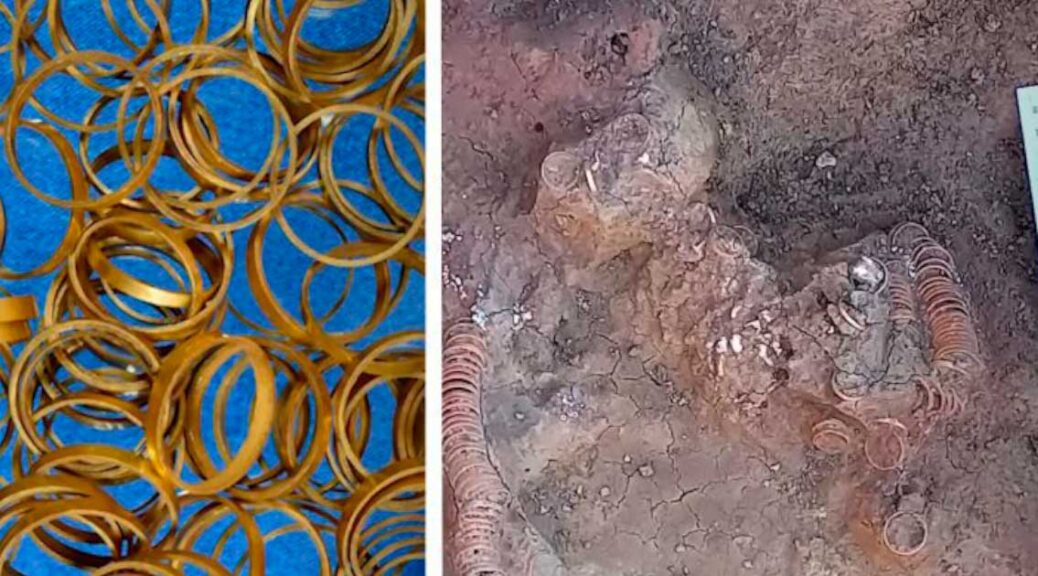
Gold rings from prehistoric Romanian tomb. Photo courtesy of the Ţării Crişurilor Museum, Oradea, Romania.
Archaeologists have made a stunning find inside a prehistoric grave in Romania: a cache of 169 gold rings, some 800 mother-of-pearl beads, and an ornate spiraled copper bracelet.
Excavations at the site, near the Biharia commune in Bihor County, Crișana, were led by archaeologist Călin Ghemiș of the Ţării Crişurilor Museum between March and June of this year, according to Heritage Daily.
“It is a phenomenal discovery. Such a treasure no longer exists in Central and Eastern Europe,” Ţării Crişurilor director Gabriel Moisa said at a press conference, according to Romanian news outlet Agerpres.
“It seems that it was the grave of a woman, extremely rich. We do not know who she was.”
The burial is believed to belong to the Copper Age Tiszapolgár culture, which flourished in Eastern and Central Europe from about 4500 to 4000 BCE.
Gold rings from prehistoric Romanian tomb. Photo courtesy of the Ţării Crişurilor Museum, Oradea, Romania.
“The gold hoard is a sensational find for the period, considering that all the gold pieces from the Carpathian Basin total around 150 pieces. Well, here there are over 160 in just one inventory,” Ghemis said.
Archaeologists identified the remains as belonging to a woman based on the size of the skeleton, and the fact that there were no weapons buried in the grave. The gold rings would have likely been used to adorn her hair.
“We want to find out what kind of culture the person belonged to, and also whether the rings were made of gold from the Transylvanian Archipelago,” Moisa added.
Gold rings being excavated from a prehistoric Romanian tomb. Photo courtesy of the Ţării Crişurilor Museum, Oradea, Romania.
The bones have been sent to laboratories in Marosvásárhely and Holland for further analysis, including carbon-14 dating and DNA testing.
The gold rings are undergoing conservation and cleaning and could go on display at the museum by year’s end.
The ancient tomb’s trove of golden treasure rivals other recent archaeological discoveries, such as the cache of 6th-century gold jewellery that an amateur metal detectorist found in Denmark in late 2020, or a similarly unearthed haul of Anglo-Saxon gold that turned up between 2014 and 2020.
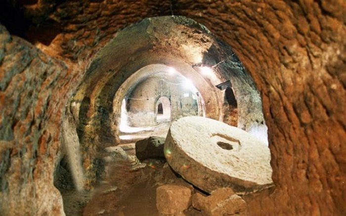
Underground Labyrinth With Secret Passages, Tunnels In Dobrogea Plateau, Romania
In many cases, the world below us is just as fascinating as the ground we walk on. Across Europe, there is a hidden, often millennia-old subterranean realm of tunnels stretching from the north in Scotland leading down to the Mediterranean.
Limanu Cave’s secret, and still unexplored passages and roads. The network gallery actually resembles a city street map, like the street network of an ancient city developed chaotically, thus the impression of an underground city.
It is an underground world of never-ending tunnels, massive caves, and labyrinths dug by unknown ancient men. There are also underground labyrinths that have not been fully explored yet. One of them is located about 52 kilometres from Constanța, historically known as Tomis, the oldest continuously inhabited city in Romania.
A Vast Underground City Where You Can Get Lost
This vast labyrinth of 12 hectares lies beneath the plateau of Limanu. Researchers started to investigate the place in 1916 and discovered traces left by humans, carved walls and ceilings, and ancient ceramic fragments. Drawings and inscriptions in Roman and Cyrillic alphabets on the walls prove the cave was inhabited between the 1st century BC and 10th century AD.
The labyrinth is vast, with a total length of passages approximately 3.5 km. Dacians used it to hide from the Roman proconsul Marcus Licinius Crassus (c. 115 B.C. —53 BC), who played a vital role in transforming the Roman Republic into the Roman Empire. The cave’s early inhabitants used a marking system to avoid getting lost.
Approximately 4,000 meters in length, Limanu Cave is the longest in Dobrogea. It has a chaotic branching of galleries, like the street network of an ancient city. Some researchers believe that at least some of the galleries were entirely dug by human beings, as there are tooling marks on the walls. Certainly, Limanu Cave represented an important human refuge, even since Dacian times.
The network of galleries resembles a city street map, like the street network of an ancient city developed chaotically, thus the impression of an underground city.
Remarkable Galleries
Some of the galleries have rectangular, very regular sections, and it seems humans carved them as signs of chiseling are visible. In order to avoid the collapse of ceilings, supporting walls and pillars were built in limestone slabs.
The drawings of galloping horses are of particular interest, while their riders have faces displayed from the front. Their silhouette and presentation strikingly resemble those of Dacian riders depicted on pottery discovered in many settlements in the area inhabited by Thraco-Dacians.
The earliest drawings are very likely from the prosperous time of the Geto-Dacian culture, the time when the cave was furnished as well. Other pictures show Christian religious symbols, letters, or words in the Cyrillic alphabet. This artwork belongs to the Roman-Byzantine period and the subsequent times.
According to Ph.D. Adina Boroneant, “Vasile Pârvan” Institute of Archaeology, Romanian Academy, the Limanu Cave was a shelter for the local population until later, 10th-11th centuries AD.
Surveys have revealed archaeological material proving that local Dacians inhabited the cave even in that era. Existing evidence allows us to assume that a local Geto-Dacian authority ordered the maze of Limanu as a defense measure against the Roman danger.” The account of Dio Cassius shows that the cave was a place of refuge, purposefully chosen and renovated, not some adventitious cavern,” Ph.D. Boroneant writes in his ‘Labirintul subterrane de la Limanu’ (The Underground Labyrinth of Limanu).
Tales Of Mysterious Sounds Coming From Underground Realms
Local stories mention strange and frightening wails like a prolonged high-pitched cry of grief, pain, or anger coming from the depths of the earth.
A scientific explanation for these strange sounds provided by speleologists is that the eerie wails are produced by the wind that sweeps through many underground galleries at Limanu. This noise affects the human psyche.
The cavern has a unique characteristic: although it is located on a complex of lakes and close to the Black Sea, it is so impenetrable that not even water can pass through.
The cave is also known as Caracicula (the old name of Limanu settlement), Bats’, or Icons’ – due to some images carved in stone that once guarded the entrance.
Limanu Cave is one of the three habitats in Romania for horseshoe bats – Rhinolophus Mehelyi. The species decreased from over 5,000 specimens to about 300 individuals. However, ecologists warned about the vulnerability of the cave, which is a magnet for treasure hunters. Through their actions, they tend to destroy the fauna.
Being located near the border with Bulgaria, Limanu cave had the reputation of a tunnel carrying fugitives across the border, particularly during the communist time.
There are many reasons to suspect the Dobrogea caves are hiding mysteries still waiting to be discovered.
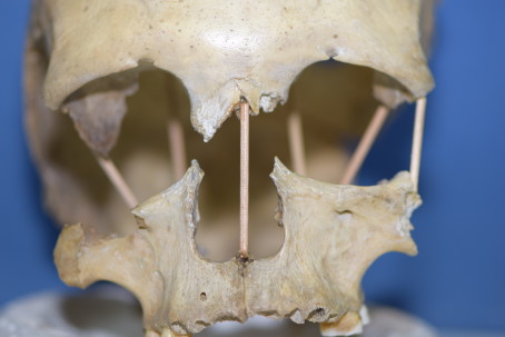
According to a statement released by Uppsala University, a team of researchers led by Mattias Jakobsson has sequenced the genome of a woman whose 35,000-year-old skull was discovered in southern Romania’s Peștera Muierri cave system in the 1950s.
For the first time, researchers have successfully sequenced the entire genome from the skull of Peştera Muierii 1, a woman who lived in today’s Romania 35,000 years ago.
Her high genetic diversity shows that the out of Africa migration was not the great bottleneck in human development but rather this occurred during and after the most recent Ice Age.
“She is a bit more like modern-day Europeans than the individuals in Europe 5,000 years earlier, but the difference is much less than we had thought.
We can see that she is not a direct ancestor of modern Europeans, but she is a predecessor of the hunter-gathers that lived in Europe until the end of the last Ice Age,” says Mattias Jakobsson, professor at the Department of Organismal Biology at Uppsala University and the head of the study.
Very few complete genomes older than 30,000 years have been sequenced. Now that the research team can read the entire genome from Peştera Muierii 1, they can see similarities with modern humans in Europe while also seeing that she is not a direct ancestor.
In previous studies, other researchers observed that the shape of her cranium has similarities with both modern humans and Neanderthals.
For this reason, they assumed that she had a greater fraction of Neanderthal ancestry than other contemporaries, making her stand out from the norm.
But the genetic analysis in the current study shows that she has the same low level of Neanderthal DNA as most other individuals living in her time. Compared with the remains of some individuals who lived 5,000 years earlier, such as Peştera Oase 1, she had only half as much Neanderthal ancestry.
The spread of modern humans out of Africa about 80,000 years ago is an important period in human history and is often described as a genetic bottleneck. Populations moved out of Africa and into Asia and Europe.
The effects of these migrations can be seen even today. Genetic diversity is lower in populations outside of Africa than in African. That Peştera Muierii 1 has high genetic diversity implies that the greatest loss of genetic diversity occurred during the last Ice Age (which ended about 10,000 years ago) instead of during the out of Africa migration.
“This is exciting since it teaches us more about the early population history of Europe. Peştera Muierii 1 has much more genetic diversity than expected for Europe at this time.
This shows that genetic variation outside of Africa was considerable until the last Ice Age and that the Ice Age caused the decrease in diversity in humans outside of Africa.”
The researchers were also able to follow the genetic variation in Europe over the last 35,000 years and see a clear decrease in variations during the last Ice Age.
The reduced genetic diversity has previously been linked to pathogenic variants in genomes being more common among populations outside of Africa, but this is in dispute.
“Access to advanced medical genomics has allowed us to study these ancient remains and even be able to look for genetic diseases. To our surprise, we did not find any differences during the last 35,000 years, even though some individuals alive during the Ice Age had low genetic diversity.
Now we have accessed everything possible from these remains. Peştera Muierii 1 is important from a cultural history perspective and will certainly remain interesting for researchers within other areas, but from a genetic perspective, all the data is now available.”
Fact Peştera Muierii
Peştera Muierii 1 is the name given to one of the three individuals whose remains were found in a cave of the same name. Peştera Muierii (roughly translates to women’s cave) is the name of a cave system in Baia de Fier in southern Romania. It is best known for the remains of cave bears and for the 1950s discovery of skulls and other skeletal parts from three females that lived about 35,000 to 40,000 years ago.
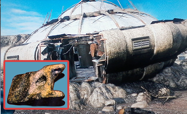
The Aiud Artifact: 2,50,000 Years Old Piece Of Machinery Found In A Fossilized Bone
The 250,000-year-old evidence that aliens once invaded Earth is hailed as a piece of aluminium that appears as though it was handmade. According to CEN, the finding of the mysterious chunk of metal in communist Romania in 1973 was not made official at the time.
After research, the item was discovered to be, to some extent, an ancient relic made of 12 metals and 90% aluminium with Romanian officials estimating it was in the range of 250,000 years old. The initial results were later confirmed by a lab in Lausanne, Switzerland, CEN reports.
Metallic aluminium was not really produced by mankind until around 200 years ago, so the discovery of the large chunk that is claimed to be up to 250,000 years old is being held up as a sensational find.
A piece aluminium that looks as if it was handmade is being hailed as 250,000-year-old proof that aliens once visited Earth
In 1973, builders working on the shores of the Mures River not far from the central Romanian town of Aiud found three objects 10 metres (33 feet) under the ground.
They appeared to be unusual and very old, and archaeologists were bought in who immediately identified two of them as being fossils. The third looked like a piece of man-made metal, although very light, and it was suspected that it might be the end of an axe.
All three were sent together with the others for further analysis to Cluj, the main city of the Romanian region of Transylvania. It was quickly determined that the two large bones belonged to a large extinct mammal that died 10,000-80,000 years ago, but experts were stunned to find out that the third object was a piece of very lightweight metal, and appeared to have been manufactured.
The object is 20 centimetres (7.8 inches) long, 12.5 centimetres (4.9 inches) wide and 7 centimetres (2.8 inches) thick
In 1973, builders working on the shores of the Mures River not far from the central Romanian town of Aiud found three objects 10 metres (33 feet) under the ground
The object is 20 centimetres (7.8 inches) long, 12.5 centimetres (4.9 inches) wide and 7 centimetres (2.8 inches) thick. What puzzled experts are that the piece of metal has concavities that make it look as if it was manufactured as part of a more complex mechanical system.
Now a heated debate is going on that the object is actually part of a UFO and proof of visitation by an alien civilisation in the past.
Gheorghe Cohal, the Deputy Director of the Romanian Ufologists Association, told local media: ‘Lab tests concluded it is an old UFO fragment given that the substances it comprises cannot be combined with technology available on Earth.’
However, local historian Mihai Wittenberger claims that the object is actually a metal piece from a World War II German aircraft. He believes that it is a piece of the landing gear from a Messerschmitt ME 262.
The UFO hunters say that this explanation does not explain the age of the artefact. The metal object has now gone on display in the History Museum of Cluj-Napoca, with a sign that reads ‘origin still unknown’.
‘It is fairly rare for people to find chunks of metal attributed to UFO crashes’, Nigel Watson author of the UFO Investigations Manual told MailOnline.
‘The (in)famous Roswell flying saucer crash of 1947 is alleged to have left wreckage that was impossible to cut or burn and would return to its original shaped if crumpled up.
‘Unfortunately, the USAF whisked all the wreckage away leaving conspiracy theorists to think that the US government has a flying saucer stashed away in Area 51.
‘If UFO wreckage is kept from the grasp of the US government, or by mystery “Men In Black”, it usually has a mundane explanation.
‘In some cases, our own satellites have crashed and have been regarded as UFO wreckage, which is a good way of keeping a space mission secret.
‘In this instance, it could be the wreckage of a satellite, and that’s why it was kept secret back in 1973.
‘As with all such cases, the debate between the UFO supporters and people with more Earthly explanations tends to rumble on without either side conceding defeat’.
1,500-Year-old lost Roman city of Altinum rises again as aerial maps reveal detailed street plan
This had been one of the Roman Empire’s richest cities. But when the mighty Germanic Emperor Attila the Hun started his assault in AD452, Altinum’s inhabitants began their great escape and fled.
The once-bustling metropolis, regarded by some scholars as to the forerunner of Venice, gradually sank into the ground and into obscurity. But now, thanks to sophisticated aerial imagery, the lost city has been brought to life once again more than 1,500 years on.
From the ground, the 100-hectare site just north of Italy’s Venice airport looks like nothing more than rolling fields of corn and soybeans. But researchers have managed to map out the remains of the buried city, revealing a detailed street plan of the city walls, the street network, dwellings, theatres, and other structures.
Archaeologists have produced aerial images using sophisticated technology revealing a detailed street plan of the ancient lost Roman city Altinum
They also show a complex network of rivers and canals, revealing how the people mastered the marshy environment in what is now the lagoon of Venice.
In July 2007 Paolo Mozzi, a geomorphologist at the University of Padua in Italy, and his team took aerial photos of the site in several wavelengths of visible light and in near-infrared.
The photos were taken during a severe drought in 2007, which made it possible to pick up the presence of stones, bricks and other solid structures beneath the surface. When the images were processed to tease out subtle variations in plant water stress, a buried metropolis emerged.
The researchers discovered that the crops planted on the land were in different stages of ripening, thanks to differences in the amount of water in the soil. Lighter crops traced the outlines of buildings – including a basilica, an amphitheater, a forum, and what may have been temples – buried at least 40 centimeters below the surface.
To the south of the city centre runs a wide strip of riper crops. They were growing above what clearly used to be a canal, an indication that Venice’s Roman forebears were already incorporating waterways into their urban fabric.
The authors note that Altinum, a trading centre that thrived between the 1st and 5th centuries AD, is the only large Roman city in northern Italy – and one of the few in Europe – that has not been buried by medieval and modern cities.
The map has enabled the researchers from the University of Padua in Italy to plot out the city walls, the street network, dwellings, theatres, rivers and canals
Some scholars have described the historic city as the precursor to ancient Venice.
The first century Roman historian Strabo mentions Altinum’s important location with its heavily travelled sea routes and roads running north to the edges of the Roman Empire making it a critical mercantile centre.
But as waves of barbarians invaded, Altinum was a ripe target and, finally, in the 7th century AD, a Lombard invasion pushed the city’s remaining residents onto the surrounding islands of the Venice lagoon.
Most of the ancient city’s stones were stolen in the Middle Ages to be reused elsewhere. Land-reclamation efforts in the 19th century turned the area from marsh into farm fields.
Previous archaeological excavations have focused mainly on the city’s necropolis, located outside the walls, but this is the first-ever glimpse of the city’s layout. Local officials are enthusiastic about the study, which was published in the Science journal.
‘Before what Professor Mozzi has done, it was impossible to imagine the complexity and distribution of the main buildings and structures of the municipium,’ Margherita Tirelli, inspector of the Archaeological Superintendence of Veneto and director of the National Archaeological Museum of Altinum told the journal.
Mozzi and his team are planning further survey work, including scans of the area with a remote-sensing technology known as LIDAR, which will help create a higher-resolution topographic map of the site.
The team also plans to sample soil at the site to see whether environmental conditions, such as flooding or drought, might have contributed to Altinum’s abandonment.
The images will help archaeologists pinpoint the best locations for future excavation.
Scientists Analyze Composition of Rome’s Clear Glass
While its fragility and elegance are in themselves intriguing, geochemical studies of the glass can show invisible tracers can reveal more than what meets the eye.
Researchers found a way to identify the origin of colorless glass from this in a new international collegial study from the Danish National Research Foundation’s Urban Network Evolutions (UrbNet), the Aarhus Geochemistry and Isotope Research Platform (AGiR) at Aarhus University, researchers have found a way to determine the origin of colourless glass from the Roman period. The study is published in Scientific Reports.
It manufactures products for drinking and dining, glass slippers, and glass colors for the wall mosaics. The Roman glass industry is extensive. One of its outstanding achievements was the production of large quantities of a colourless and clear glass, which was particularly favoured for high-quality cut drinking vessels.
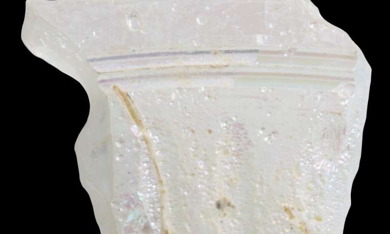
One of the colorless Roman glass sherds from Jerash, Jordan, analyzed in this study. Purple splashes are iridescence due to weathering.
The fourth-century Price Edict of the emperor Diocletian refers to colourless glass as ‘Alexandrian’, indicating an origin in Egypt. However, large amounts of Roman glass are known to have been made in Palestine, where archaeologists have uncovered furnaces for colourless glass production.
Such furnaces have not been uncovered in Egypt, and hitherto, it has been very challenging to scientifically tell the difference between the glass made in the two regions.
Now, an international collaboration led by Assistant Professor Gry Barfod from UrbNet and AGiR at Aarhus University has found the solution.
Their work on Roman glass from the Danish-German Jerash Northwest Quarter Project in Jordan shows that the isotopes of the rare element hafnium can be used to distinguish between Egyptian and Palestinian glass and provide compelling evidence that the prestigious colourless glass known as ‘Alexandrian’ was indeed made in Egypt.
Two of the co-authors of the publication, Professor Achim Lichtenberger (University of Münster) and Centre Director at UrbNet Professor Rubina Raja, head the archaeological project in Jerash, Jordan. Since 2011, they have worked at the site and have furthered high-definition approaches to the archaeological material from their excavations.
Through full quantification methods, they have over and again shown that such an approach is the way forward in archaeology when combining it with in context studies of various material groups.
The new study is yet another testament to this approach.
“Hafnium isotopes have proved to be an important tracer for the origins of sedimentary deposits in geology, so I expected this isotope system to fingerprint the sands used in glassmaking”, states Gry Barfod.
Professor at Aarhus University Charles Lesher, co-author of the publication, continues: “The fact that this expectation is borne out by the measurements is a testament of the intimate link between archaeology and geology.”
Hafnium isotopes have not previously been used by archaeologists to look at the trade-in ancient man-made materials such as ceramics and glass. Co-author Professor Ian Freestone, University College London, comments, “These exciting results clearly show the potential of hafnium isotopes in elucidating the origins of early materials. I predict they will become an important part of the scientific toolkit used in our investigation of the ancient economy.”
The sand along the Mediterranean coast of Egypt and Levant (Palestine, Israel, Lebanon and Syria) originates from the Nile and is ideal for glass production because it naturally contains the amount of lime needed to keep the glass stable and not degradable.
In the Levant, they made transparent glass by adding manganese – it was good, but not perfect.
The second type of Roman glass, which scientists now show came from Egypt, the glassmakers made transparent by adding antimony (Sb), which made it crystal clear; therefore, this was the most valuable glass.
Alaskan volcano eruption linked to fall of Roman Republic: Study
The proof of an unprecedented period of extreme cold in ancient Rome has come to light through a multinational team of scientists and historians: an unlikely cause of the mass explosion of the Alaska Okmok volcano on the opposite side of the world.
Written sources identify a period of exceptionally cold weather, crop failures, drought, plague and anarchy in the Mediterranean region around the time of Julius Caesar’s death (44 BCE)—impacts that eventually led to the downfall of the Roman Republic and the Ptolemaic Kingdom of Egypt.
Historians have long suspected a volcano to be the cause, but have been unable to pinpoint where or when such an eruption had occurred, or how severe it was.
Cicero’s death in 42 B.C.E. marks the end of the Roman Republic. Did a volcano hasten its fall?
In a new study published this week in Proceedings of the National Academy of Sciences (PNAS), a research team led by Joe McConnell, Ph.D. of the Desert Research Institute in Reno, Nev. uses an analysis of tephra (volcanic ash) found in Arctic ice cores to link the period of unexplained extreme climate in the Mediterranean with the caldera-forming eruption of Alaska’s Okmok volcano in 43 BCE.
“To find evidence that a volcano on the other side of the earth erupted and effectively contributed to the demise of the Romans and the Egyptians and the rise of the Roman Empire is fascinating,” McConnell said. “It certainly shows how interconnected the world was even 2,000 years ago.”
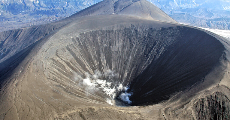
Alaska’s Umnak Island in the Aleutians showing the huge, 10-km wide caldera (upper right) largely created by the 43 BCE Okmok II eruption at the dawn of the Roman Empire.
The discovery was initially made last year in DRI’s Ice Core Laboratory, when McConnell and Swiss researcher Michael Sigl, Ph.D. from the Oeschger Centre for Climate Change Research at the University of Bern happened upon an unusually well-preserved layer of tephra in an ice core sample and decided to investigate.
New measurements were made on ice cores from Greenland and Russia, some of which were drilled in the 1990s and archived in the U.S., Denmark, and Germany.
Using these and earlier measurements, they were able to clearly delineate two distinct eruptions – a powerful but short-lived, relatively localized event in early 45 BCE, and a much larger and more widespread event in early 43 BCE with volcanic fallout that lasted more than two years in all the ice core records.
The researchers then conducted a geochemical analysis of the tephra samples from the second eruption found in the ice, matching the tiny shards with those of the Okmok II eruption in Alaska – one of the largest eruptions of the past 2,500 years.
“The tephra match doesn’t get any better,” said tephra specialist Gill Plunkett, Ph.D. from Queen’s University Belfast. “We compared the chemical fingerprint of the tephra found in the ice with tephra from volcanoes thought to have erupted about that time and it was very clear that the source of the 43 BCE fallout in the ice was the Okmok II eruption.”
Detailed records of past explosive volcanic eruptions are archived in the Greenland ice sheet and accessed through deep-drilling operations.
Working with colleagues from the U.K., Switzerland, Ireland, Germany, Denmark, Alaska, and Yale University in Connecticut, the team of historians and scientists gathered supporting evidence from around the globe, including tree-ring-based climate records from Scandinavia, Austria, and California are the White Mountains and climate records from a speleothem (cave formations) from Shihua Cave in northeast China.
They then used Earth system modeling to develop a more complete understanding of the timing and magnitude of volcanism during this period and its effects on climate and history.
According to their findings, the two years following the Okmok II eruption were some of the coldest in the Northern Hemisphere in the past 2,500 years, and the decade that followed was the fourth coldest. Climate models suggest that seasonally averaged temperatures may have been as much as 7oC (13oF) below normal during the summer and autumn that followed the 43 BCE eruption of Okmok, with summer precipitation of 50 to 120 percent above normal throughout Southern Europe, and autumn precipitation reaching as high as 400 percent of normal.
“In the Mediterranean region, these wet and extremely cold conditions during the agriculturally important spring through autumn seasons probably reduced crop yields and compounded supply problems during the ongoing political upheavals of the period,” said classical archaeologist Andrew Wilson, D.Phil. of the University of Oxford. “These findings lend credibility to reports of cold, famine, food shortage, and disease described by ancient sources.”
“Particularly striking was the severity of the Nile flood failure at the time of the Okmok eruption, and the famine and disease that was reported in Egyptian sources,” added Yale University historian Joe Manning, Ph.D. “The climate effects were a severe shock to an already stressed society at a pivotal moment in history.”
Timeline showing European summer temperatures and volcanic sulphur and ash levels in relation to the Okmok II Eruption and significant historic events of the Roman Republic and Ptolemaic Kingdom from 59 to 20 BCE.
Volcanic activity also helps to explain certain unusual atmospheric phenomena that were described by ancient Mediterranean sources around the time of Caesar’s assassination and interpreted as signs or omens – things like solar halos, the sun darkening in the sky, or three suns appearing in the sky (a phenomenon now known as a parahelia, or ‘sun dog’). However, many of these observations took place prior to the eruption of Okmok II in 43 BCE, and are likely related to a smaller eruption of Mt. Etna in 44 BCE.
Although the study authors acknowledge that many different factors contributed to the fall of the Roman Republic and Ptolemaic Kingdom, they believe that the climate effects of the Okmok II eruption played an undeniably large role – and that their discovery helps to fill a knowledge gap about this period of history that has long puzzled archaeologists and ancient historians.
“People have been speculating about this for many years, so it’s exciting to be able to provide some answers,” McConnell said.
Metal Detectorist Finds Rare Lost Roman Lead Ingot in Wales
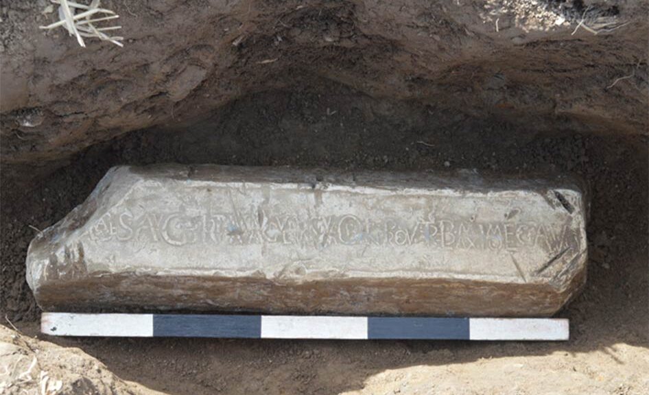
In a field near Rossett, Rob Jones found the metal object, and a careful searching exposed the corner of a lead object with ‘writing’ on it.
The local find agent (NE Wales) has informed Mr. Jones who is from Codpoeth, Wrexham to the Wales Portable Antiquity Scheme (PAS Cymru) located in the Wrexham Museum. Archaeologists from both the Museum and the Clwyd-Powys Archaeological Trust assessed what had been discovered.
The item discovered was a large lead ingot (approximately half a meter long and 63 kilograms weighed). The ‘writing’ reported by Mr. Jones was a cast Latin inscription confirming that it was Roman and about 2,000 years old.
The discovery is assessed alongside its finder, Metal detectorist Rob Jones.
The exploitation of Britain’s natural resources was one of the reasons cited by Roman authors for the invasion of Britain by Emperor Claudius in AD 43.
Lead ore or galena contains silver as well as lead, and both were valuable commodities for the Romans. Less than a hundred lead ingots of this type are known from the mines of Roman Britain.
The rare find is particularly significant for archaeologists and historians because of its potentially early date, the location of the findspot, and because of its unique inscription.
The lead was mined and processed in several areas of the new province including in north-east Wales where lead processing sites have been excavated near Flint, presumably smelting ores extracted from the nearby Halkyn Mountain.
A number of lead ingots of slightly later date are known from these works, often marked with the name of the local pre-Roman tribe called the Deceangli.
Susie White, the local Finds Officer (NE Wales) said: “It has been suggested in the past that similar exploitation took place in the Wrexham area around Minera and particularly Ffrith, where there is a known Roman site, although clear evidence is absent, probably as the result of more recent mining activity.
“We don’t yet know where this ingot has come from and we will probably never know where it was going to. However given the find spots of other ingots from Britain of similar date, it may have been destined for continental Europe, perhaps even Rome itself. The object could tell us a great deal about this important period of our past, a period which is still poorly understood in this area of the country.”
The inscription appears to mention one Marcus Trebellius Maximus, who was the governor of the province of Britannia under Emperor Nero from AD 63-69.
If genuine, the Rossett find represents the only example of an inscription bearing his name ever found in the UK and one of very few from the empire as a whole.
Trebellius was partly responsible for bringing stability to Britannia after Boudica’s revolt in AD 60/1, although he was ultimately forced out of the province by mutinous Roman soldiers who were dissatisfied with the lack of military activity under his governorship.
Councillor Hugh Jones, Lead Member for People at Wrexham Council commented “I’m delighted to be able to announce that Wrexham museum has acquired the ingot and I’d like to thank the Arts Council England/V&A Purchase Grant Fund, the Headley Trust and the Friends of Wrexham Museums for their support with the acquisition which otherwise would not have been possible. Its acquisition will allow the ingot to be displayed in the town nearest to the place where it was lost and rediscovered.”
The museum together with the University of Chester is hoping to undertake archaeological work on the site of the discovery, as soon as the pandemic allows, to see if any further information can be gleaned as to the circumstances of its loss.