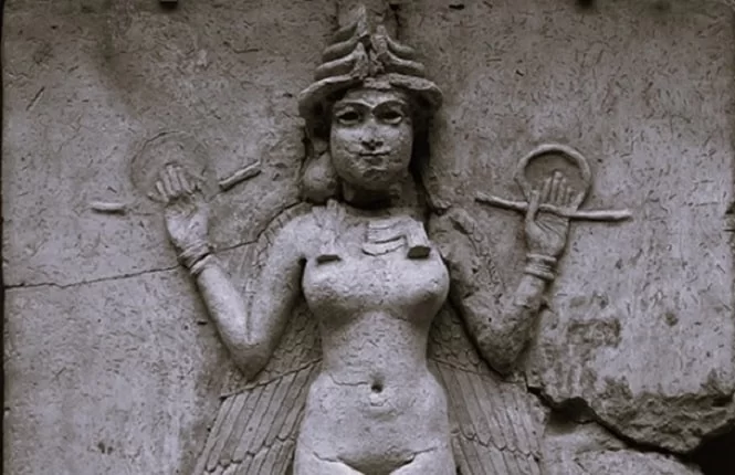
A large stone monument depicting the goddess Ishtar has been unearthed in the ancient Assyrian city of Nimrud
Archaeologists from the University of Pennsylvania Museum of Archeology and Anthropology, working with an Iraqi excavation team, have unearthed a large stone monument depicting the goddess Ishtar in the ancient Assyrian city of Nimrud.
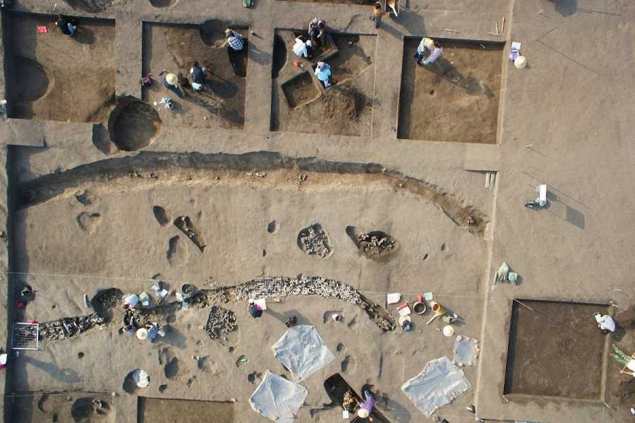
Archaeologists have uncovered more monumental finds in Nimrud, one of the heritage sites severely damaged by the so-called Islamic State (ISIS) in northern Iraq.
Among the new relics discovered at the site are those from a 3,000-year-old temple dedicated to Ishtar, the Mesopotamian goddess of love and war and the goddess with the earliest written evidence.
During earlier excavations in Nimrud, the same team revealed a 2,800-year-old palace belonging to an Assyrian king Adad-Nirari III, who reigned from 810–783 BCE.
This season, the team continued working inside the palace and expanded its efforts to include the Temple of Ishtar, which burned when Nimrud was sacked by an invading army in 612 BCE.
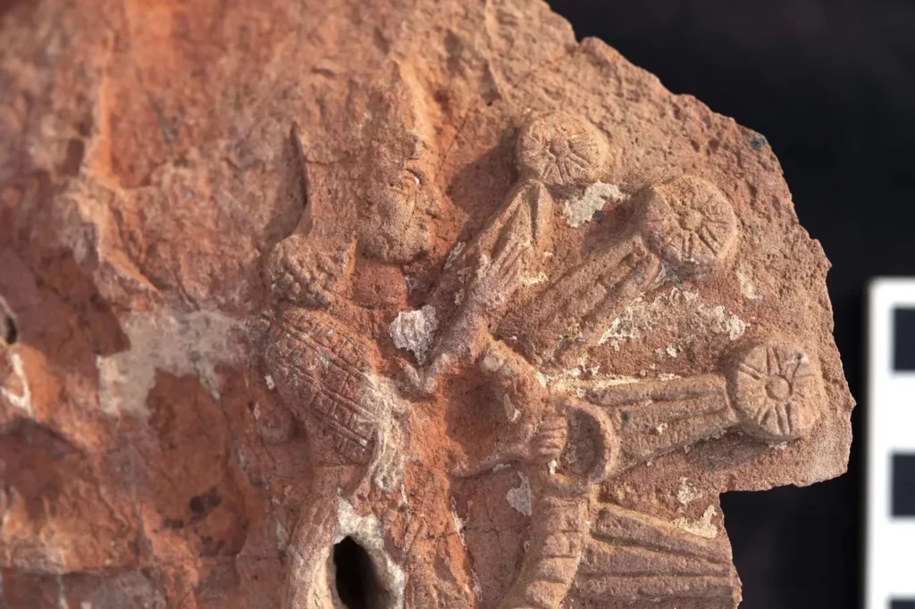
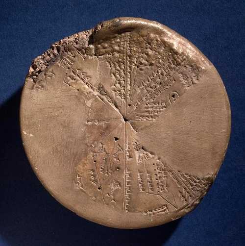
A fragment of the stone stele depicting Ishtar inside a starburst.
Chief among their finds were fragments of a large stone monument that depicts the goddess Ishtar inside a star symbol.
“Our greatest find this season was a spectacular fragment from the stone stele that shows the goddess Ishtar inside a star symbol. This is the first unequivocal depiction of the goddess as Ishtar Sharrrat-niphi, a divine aspect of the goddess associated with the rising of the planet Venus, the ‘morning star,’ to be found in this temple dedicated to her,” Dr. Michael Danti, Program Director of the Iraq Heritage Stabilization Program and archeologists at the University of Pennsylvania, said in a statement.
This season’s new discoveries largely focus on the splendor of Adad-Nirari III’s rule and ancient Nimrud’s affluence.
Two enormous stone column bases that the archaeologists discovered suggest the palace was grandly decorated with exquisitely carved columns.
Evidence of a sizable stone basin, which the researchers think may have served as a central heating system, was found inside the throne room.
In addition, they discovered scattered pieces of ostrich eggshell and ivory, both of which were rare and would have been extremely valuable in the early Bronze Age.
Mysterious 18-Km-Long Underground City Found In Iran: Could be At Least 6000 Years Old
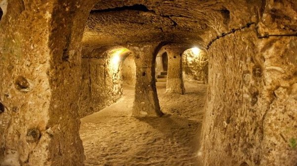
In Bam village of Esfarayen county in northeast Iran, a routine road construction project has led to an exciting discovery of a vast network of underground corridors linked to the nearby fortress of Shahr-e Belqeys (City of Belqeys).
The discovery was made by workers laying a road in 2022, who stumbled upon this precious heritage from a different spot after access was blocked by the local cultural heritage directorate last year to protect it.
The expert at the Belqeys archaeological site confirmed that the total length of the corridors was 18 kilometers (11 miles), and that a bathroom and a mill were located along the extent. However, these have not been opened yet, and experts are yet to examine them.
“Last years, traces of this underground city had been discovered, but to protect it, these remains were blocked by the local cultural heritage directorate. Now we reached these ancient structures from another place, which confirms the statements of the local people,” the expert explained. “The ruins have yielded potteries estimated to belong to the Seljuk period, IlKhanid, and even earlier periods. However, an extensive archaeological excavation is needed to delve into its secrets.”
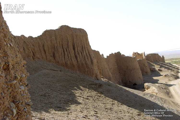
The ruined citadel of Shahr-e Belqeys is located in the northeastern part of North Khorasan province and is spread over 51,000 square meters (12.6 acres). It is the second-largest mud fortress in Iran after the UNESCO World Heritage Site Bam Citadel. Based on excavations at nearby hilltops and elevations, the citadel is believed to be at least 6,000 years old.
Ruined citadel of Shahr-e Belqys, site of the underground corridor discovery.
The fortress is considered to have flourished from the late Sassanid era (224-661 AD) to the early Islamic period in the 7th century and had been active until Nader Shah Afshar assumed power in the early 18th century. Historical evidence suggests that Belqeys enjoyed the favor of Sassanid monarchs, leading to its prosperity.
Several excavations in Belqeys have revealed the remarkable remains of the citadel, houses, irrigation channels, a cistern, and a hypostyle hall. The expert at the Belqeys site stated that the ruins have yielded potteries estimated to belong to the Seljuk period, IlKhanid, and even earlier periods, and that an extensive archaeological excavation is needed to delve into its secrets.
Iran has several underground architectural sites, including the cone-shaped underground homes of Kandovan village in north-western Iran, which resemble the “fairy chimneys” of Cappadocia in Turkey, where Bronze Age cave dwellers built famous underground cities.
The underground corridors found near Shahr-e Belqeys are similar to those built during the same period in Nushabad.
In 2018, the 3rd International Troglodytic Architecture Conference was held in Iran, bringing scores of experts and scholars to discuss subterranean architecture, technology, and culture. The discovery of the underground corridors in Shahr-e Belqeys is just one of the many exciting examples of Iran’s rich cultural heritage. It has again opened up new avenues for research and discovery in archaeology.
Another underground site in Iran is the fascinating city of Nushabad, also known as Ouyi, located in Isfahan province in central Iran. This entire city of passages and chambers is located at depths varying from 4 to 18 meters (13 to 59 feet) and dates back to Sassanid times.
Nushabad is a city named after the cold and refreshing water from a local well or spring. It was founded by a Sassanian king who passed through the area and was impressed by the water. The city was a place of refuge for people in the surrounding desert during the hot summer months.
As time passed, the underground city of Nushabad became more than just a source of fresh water and a place to escape the heat. It also served as a haven during times of war. Throughout the history of Iran, the city faced numerous invasions from attackers who would come to pillage and kill.
For example, during the Mongol invasion in the 13th century, when the invaders arrived at the above-ground city, they found it deserted as its residents had fled to the safety of Nushabad. This pattern continued until the Qajar period.
Nushabad was well equipped to serve as a refuge, with features that made it difficult for attackers to enter. For instance, the city had multiple entry points, but they were so narrow that only one person could go in at a time. This prevented an invading army from using their superior numbers to overpower those hiding in the underground city.
Additionally, there are ventilation shafts that allow airflow in and out of Nushabad, whilst fresh water is provided by the spring. This meant that refugees were able to stay in the underground city for long periods of time. It has also been suggested that there would have been some storage areas for food as well. Various rooms have also been found along the carved-out pathways of the city, and ledges have been dug out to serve as benches/beds for people.
The similarity in construction between the Shahr-e Belqeys underground corridors and Nushabad leads experts to believe that they served the same purpose. Further excavations, pending the approval of the Iranian government, will provide more insight into their architecture and use.
The discovery of the extensive network of underground corridors in Bam village is a significant finding that could shed light on the ancient history of Iran and its cultural heritage. The fact that it was discovered by accident during a routine road construction project makes it even more exciting. It will generate great interest among archaeologists and history buffs for sure.
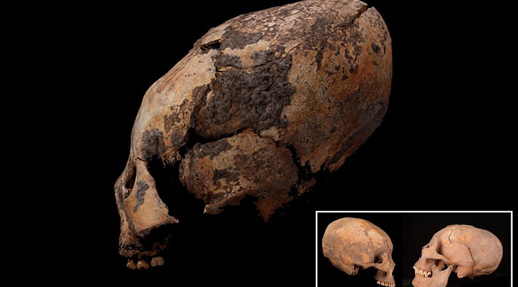
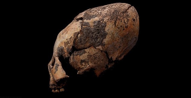
12,000 Years Ago, Mysterious Egg-Headed People Inhabited China
Archaeologists excavated 25 human skeletons with elongated skulls dating back perhaps as long as 12,000 years ago from Houtaomuga archaeological site in northeast China.
The strange shape of the skulls symbolizes a part of the ritual in ancient China. The discovery provides additional proof that cranial alterations were prevalent in ancient East Asia and was a customary practice throughout the world during prehistoric times.
According to a study published in the American Journal of Physical Anthropology in 2019, a team of researchers, led by bioarchaeologist Quanchao Zhang and paleoanthropologist Qian Wang, discovered 25 skeletons at a location known as Houtaomuga.
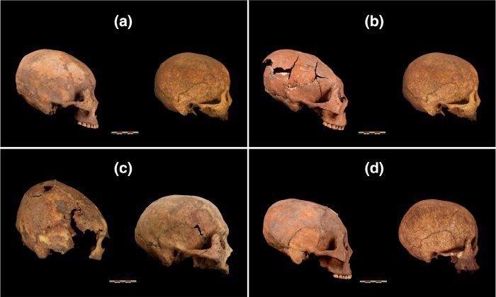
The remains were dated between approximately 12,000 and 5,000 years ago. Out of the 25 skeletons, 11 had skulls that had been intentionally elongated, with flattened bones at both the front and back of the head.
The researchers from China’s Jilin University and Texas A&M University who conducted the excavations were surprised at the abundance of “anomalies” and suggested that many were “egg-shaped.”
Study co-researcher Qian Wang, an associate professor in the Department of Biomedical Sciences at the Texas A&M University College of Dentistry said: “This is the earliest discovery of signs of intentional head modification in Eurasia continent, perhaps in the world.
If this practice began in East Asia, it likely spread westward to the Middle East, Russia, and Europe through the steppes as well as eastward across the Bering land bridge to the Americas.”
The M72 skull is between 6,300 and 5,500 years old.
The Chinese civilization is one of the most ancient and continuous in the world. While their recorded history can be traced back to the 5th century BC, with the emergence of the Zhou dynasty, there is archaeological evidence that suggests their history dates back even further.
The earliest documented records refer to semi-mythical people called the “Yellow Emperor” and his beastly advisors – known as the “Foolish Old Men.”
Currently, the Chinese egg-shaped skulls are considered to be the oldest in the world. Besides, it was noted that the tradition of stretching heads had been formed long before the Neolithic Revolution (First Agricultural Revolution) took place. It was believed that the tradition of skull modification started around 9,000 years ago.
According to Archaeology, the discovered skulls exhibited artificially elongated braincases and flattened bones at both the front and back of the head.
The researchers identified three different types of cranial deformations in eleven of the skulls. Out of these 11, five were adults, with one female and others male. The remaining skulls belonged to children, and the ages of the individuals varied from 3 to 40 years old.
Scientists still do not know why in ancient times people deliberately pulled their skulls out and where it started. The children’s heads were clamped in a special vice or in a device of two boards. In the process, not only the bones of the skull were stretched, but also the inside structure deformed. At the same time, the bones of the skull became very thin.
It is still unknown how the tradition of artificially modified skull start.
Archaeologists believed that humans with deformed skulls were trained to perform important social roles. For example, to become priests of a certain cult.
They believed that elongated skulls would open some unusual abilities, and allow them to communicate with higher powers. At least, people probably thought that by pulling back their heads, they acquire a strong social status in their society.
For centuries, our ancestors utilized various wooden, rag, and rope techniques to scar their own and their children’s heads, seeking aesthetic enhancement. The desire for such body modification has persisted worldwide for thousands of years, with some still practicing it, especially in Africa.
The reason behind this practice remains uncertain, puzzling scientists who can only surmise that some compelling motivation drove our forebears to endure such pain. Even though the Houtaomuga man is the oldest known case of deliberate skull reshaping in history, it is a mystery whether other known instances of deliberate skull reshaping spread from this group, or whether they rose independently of one another, Wang said.
An excavation at the site in 2010.
Oddly shaped, intentionally modified skulls have been discovered in various regions across the globe. While assertions from the 1980s contended that two Neandertal skulls, estimated to be around 45,000 years old, had been reshaped during infancy, numerous scholars have since refuted these claims.
The most ancient skulls that exhibit widely acknowledged indications of cranial modification date back to approximately 13,000 to 10,000 years ago in the western areas of Asia, southeastern Australia, and most recently, East Asia. On the other hand, this practice began over 8,000 years ago in the Americas.
Despite the popular belief that the elongated skull, thought to be around 12,000 years old, was intentionally altered, some experts disagree. Although the skull does display some elongation, it is not significant enough to suggest intentional deformation. In fact, evidence only supports forced skull modification in those dating back 6,000 years ago.
The peculiar case of “Paracas skulls” is another discovery of elongated skulls, however, it is different from the rest of skull elongation cases.
The size of the cranium of Paracas skulls is significantly larger, by 25% and 60% heavier than typical human skulls, which indicates that they were not artificially altered through head flattening. Moreover, these skulls possess a single parietal plate, instead of two. Due to the absence of any cranial deformation, the elongation of these skulls remains unexplained and has been so for many years.
The significance of the discovery in Houtaomuga remains noteworthy, irrespective of the ongoing controversy. It highlights the existence of deliberate skull alterations during the Neolithic period in the region. Additionally, the findings offer insights into the community’s culture and convictions during the latter phase of the Stone Age.
5,500-Year-Old Sumerian Star Map History in Recorded: The Impact Of A Massive Asteroid
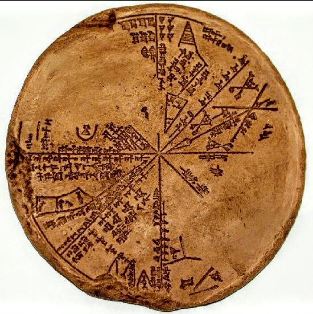
For more than 150 years scientists have tried to solve the mystery of a notorious cuneiform clay tablet that reveals that in the past the impact case of so-called Köfel was detected. The circular stone-cast tablet was discovered in the late 1800s from the 650 BC King Ashurbanipal‘s underground library in Nineveh, Iraq.
Data processing, which was long believed to be an Assyrian tablet, mirrored the sky over Mesopotamia in 3300 BC and proved to be much more ancient in Sumerian origin.
The tablet is the first astronomical instrument, the “Astrolabe.” It consists of a segmented, disk-shaped star chart with marked units of angle measure inscribed upon the rim.
Unfortunately, considerable parts of the planisphere on this tablet are missing (approximately 40%), damage which dates to the sacking of Nineveh. The reverse of the tablet is not inscribed.
Still under study by modern scholars, the cuneiform tablet in the British Museum collection No K8538 (known as “the Planisphere”) provides extraordinary proof for the existence of sophisticated Sumerian astronomy. In 2008 two authors, Alan Bond and Mark Hempsell published a book about the tablet called “A Sumerian Observation of the Kofels’ Impact Event”.
Raising a storm in archaeological circles, they re-translated the cuneiform text and assert the tablet records an ancient asteroid strike, the Köfels’ Impact, which struck Austria sometime around 3100 BC.
The giant landslide centered at Köfels in Austria is 500m thick and five kilometers in diameter and has long been a mystery since geologists first looked at it in the 19th century.
The conclusion drawn by research in the middle 20th century was that it must be due to a very large meteor impact because of the evidence of crushing pressures and explosions. But this view lost favor as a much better understanding of impact sites developed in the late 20th century.
In the case of Köfels, there is no crater, so to modern eyes, it does not look as an impact site should look. However, the evidence that puzzled the earlier researchers remains unexplained by the view that it is just another landslide.
So what is the connection between the sophisticated Sumerian star chart discovered in the underground library in Nineveh and the mysterious impact that took place in Austria?
Examination of the clay tablet reveals that it is an astronomical work as it has drawings of constellations on it and the text has known constellation names. It has attracted a lot of attention but in over a hundred years nobody has come up with a convincing explanation as to what it is.
With modern computer programs that can simulate trajectories and reconstruct the night sky thousands of years ago, researchers have established what the Planisphere tablet refers to. It is a copy of the night notebook of a Sumerian astronomer as he records the events in the sky before dawn on 29 June 3123 BC (Julian calendar).
Half the tablet records planet positions and cloud cover, the same as any other night, but the other half of the tablet records an object large enough for its shape to be noted even though it is still in space.
The astronomers made an accurate note of its trajectory relative to the stars, which to an error better than one degree is consistent with an impact at Köfels. The observation suggests the asteroid is over a kilometer in diameter and the original orbit about the Sun was an Aten type, a class of asteroid that orbit close to the Earth, that is resonant with the Earth’s orbit.
This trajectory explains why there is no crater at Köfels. The incoming angle was very low (six degrees) which means the asteroid clipped a mountain called Gamskogel above the town of Längenfeld, 11 kilometers from Köfels, and this caused the asteroid to explode before it reached its final impact point. As it traveled down the valley it became a fireball, around five kilometers in diameter (the size of the landslide). When it hit Köfels it created enormous pressures that pulverized the rock and caused the landslide but because it was no longer a solid object it did not create a classic impact crater.
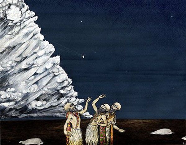
Mark Hempsell, discussing the Köfels event, said: “Another conclusion can be made from the trajectory. The back plume from the explosion (the mushroom cloud) would be bent over the Mediterranean Sea re-entering the atmosphere over the Levant, Sinai, and Northern Egypt.
“The ground heating though very short would be enough to ignite any flammable material – including human hair and clothes. It is probable more people died under the plume than in the Alps due to the impact blast.”
In other words, the remarkable ancient star map shows that the Sumerians made an observation of an Aten asteroid over a kilometer in diameter that impacted Köfels in Austria in the early morning of 29th June 3123 BC.
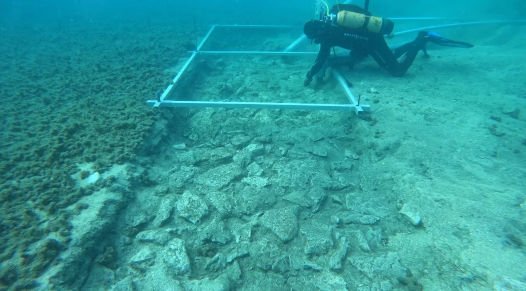
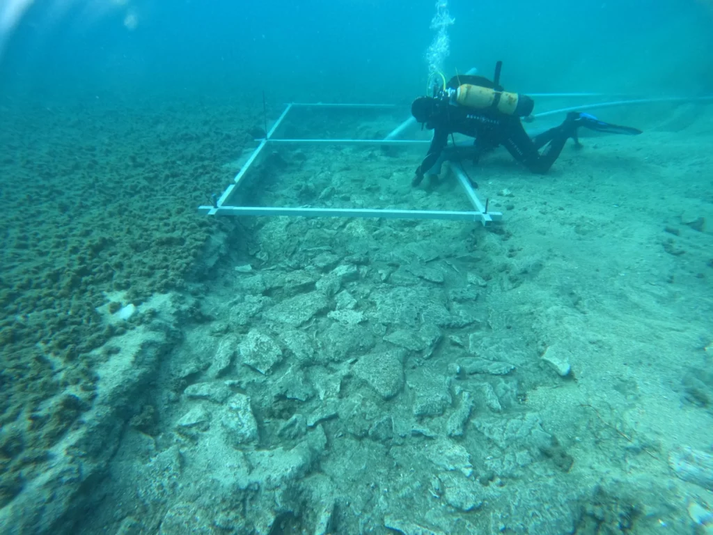
Underwater Archaeologists Discover a 7,000-Year-Old Road in Croatia
A team of underwater archaeologists from the University of Zadar has discovered the sunken ruins of a 7,000-year-old road that once linked an ancient artificial landmass to the Croatian island of Korčula.
The road is located at a depth of 5 meters in sediment deposits at the submerged archaeological site of Soline, an artificial landmass and Neolithic settlement of the island Korčula and along with several other artifacts, belonged to a lost maritime culture known as the Hvar, who occupied this area during the Neolithic Era.
By radiocarbon analysis of preserved wood found in the last campaign, the entire settlement was dated around 4,900 years before Christ.
A four-meter-wide linear road made of stone slabs was discovered during a recent underwater survey of the site. People walked on this road almost 7,000 years ago.
Over the weekend, the University of Zadar released new footage of the underwater passage, which was made of stacked stones and measured some 12 feet across.
“In underwater archaeological research of the submerged neolithic site of Soline on the island of Korčula, archaeologists found remains that surprised them,” said the University of Zadar in a statement posted to Facebook on Sunday.
“Namely, beneath the layers of sea mud, they discovered a road that connected the sunken prehistoric settlement of the Hvar culture with the coast of the island of Korčula.”
According to the university, several scientists and organizations are working together on underwater research, which is being directed by archaeologist Mate Parica, who has been studying the location for a while.
The team also found fragments of millstones, flint blades, and stone axes among the underwater ruins.
The artifacts shed light on the enigmatic Hvar peoples, who first appeared on the islands and coasts of the northeast Adriatic Sea around 7,000 years ago.
Korčula is part of an archipelago in the Adriatic that was once a part of the continent.
The coastal valleys of the Dinaric Mountains began to flood as a result of the Earth’s ice cap melting after 12,000 BC, and by 6000 BC the archipelago had roughly reached its current configuration.
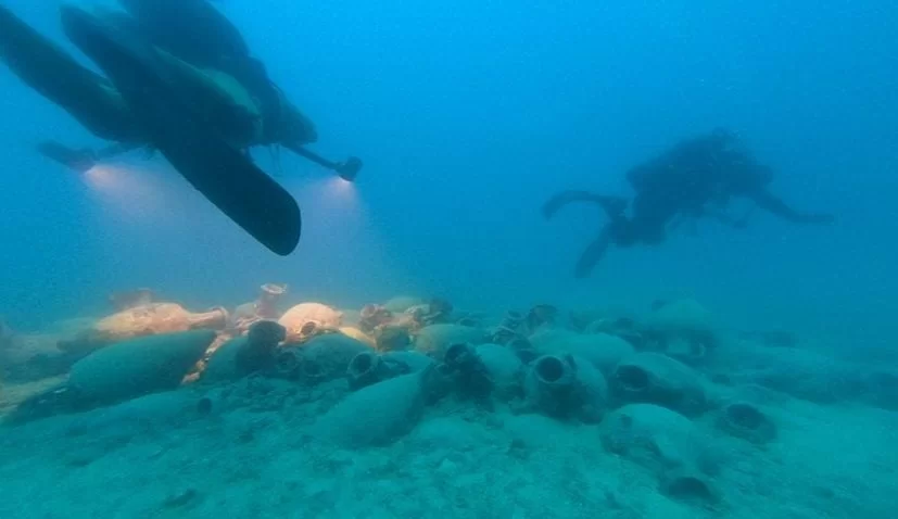
Mine-clearance divers discovered an ancient shipwreck dating from the 3rd century BC
As a result of collaborative training exercises between Croatian and Italian naval mine-clearance divers, one of the earliest fully preserved shipwrecks in the eastern Adriatic seabed has been discovered.
A previously undiscovered shipwreck containing a cargo of ancient amphorae from the 3rd century BC has been found in the waters of the Šćedra Island archipelago, just off the southern coast of Hvar island, the Croatian Ministry of Culture and Media announced in a statement on Friday.
The discovery was made as part of a long-standing collaboration in which Croatian divers have been operating from Italian minehunter vessels in a NATO mine counter-measures group in recent years.
The first of two weeks’ joint training had covered mine-clearance procedures using ROVs and AUVs near Čiovo Island, before the naval divers turned their attention to the Šćedra Island archipelago off Hvar during the week of 15-21 June.
Amphora above 3rd-century BC shipwreck.
Using mine clearance procedures and various types of equipment such as underwater autonomous vehicles and remotely operated underwater vehicles, the first week focused on joint conditioning training in the waters near Čiovo Island, while the second week involved diving activities in the waters around Hvar Island.
The success of the cross-border cooperation was viewed as an opportunity to involve bodies other than Croatia’s Ministry of Defence, so the conservation department of the Ministry of Culture and Media provided the military with information about existing and potential archaeological sites.
Despite the adverse weather conditions, a multi-layered seabed scanning operation was completed.
Several potential marks were identified, and these were followed up using a sonar- and camera-equipped ROV before scuba diving was carried out by both Croatian and Italian mine-clearance personnel.
One of these investigations resulted in finding the previously unsuspected wreck.
Underwater archaeologists from the Ministry of Culture and Media, Saša Denegri, and from the University of Split, Tea Katunarić Kirjakov, conducted dives at the specific location and confirmed that the shipwreck is fully preserved and dates back to the 3rd century BC, containing a cargo of ancient amphorae. It rests at a depth of 50 meters.
This is one of the earliest fully preserved shipwrecks on the eastern Adriatic Sea coast, taking into account the dating and preservation of the site.
Plans for the site’s protection, conservation, and presentation will be developed based on the precise context, extent, and characteristics of the site, which will be determined by future archaeological research.
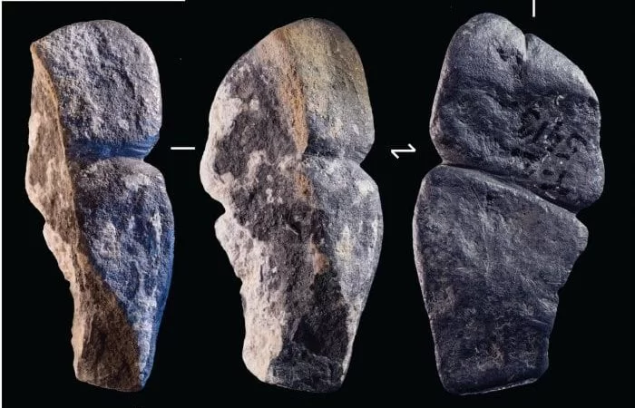
A 42,000-year-old pendant found in northern Mongolia may be the earliest known phallic art
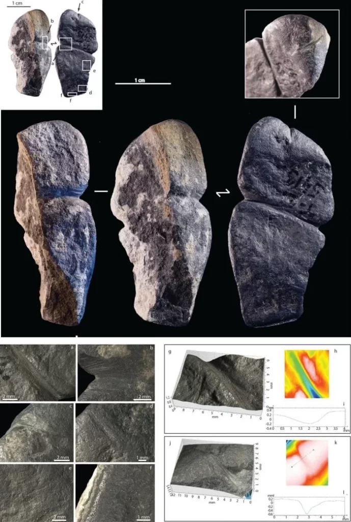
An international team of researchers has found a pendant in northern Mongolia that may be the earliest known example of a carved phallus. This pendant suggests that for at least 42,000 years, our species has been artistically depicting the penis.
The stone was found at a dig site in northern Mongolia’s Khangai Mountains. The piece of ornament interpreted as a phallus-like representation is about 4.3 centimeters long and made by humans.
According to researchers behind a study of the pendant, published this week in Nature Scientific Reports, the carved graphite is the “earliest-known sexed anthropomorphic representation.”
The dating of the material shows it was from approximately 42,400 to 41,900 years ago, putting its creation in the Upper Paleolithic.
Three-dimensional phallic pendants are unknown in the Paleolithic record. It attests that hunter-gatherer communities used sex anatomical attributes as symbols at a very early stage of their dispersal in the region.
The pendant was produced during a period that overlaps with age estimates for early introgression events between Homo sapiens and Denisovans, and in a region where such encounters are plausible,” the science team wrote in the study published in Nature.
Microscopic images of the modifications observed on the graphite pendant: (a–b) mid-section groove, (c) short groove located at one extremity of the artefact, (d–e) parallel striations observed on the flat side of the artefact, (f) highly smoothed and shiny facet present on the flat side of the artefact, (g) 3D reconstruction of the mid-section groove, (h–i) profile of the mid-section groove, (j) 3D reconstruction of the groove located at one extremity of the artefact, (k–l) profile of the groove located at one extremity of the artefact. Credit: Scientific Reports. DOI: 10.1038/s41598-023-36140-1
The black pendant has several grooves, but two of them caught the attention of scientists.
Researchers think these grooves were carved into the stone to make it resemble a human penis. But not everyone is convinced that the Mongolian pendant represents a phallus.
Solange Rigaud, an archaeologist at the University of Bordeaux and the study’s lead author, thinks the strongest argument for the pendant as a phallic representation comes from the features its maker focused on.
“Our argument is that when you want to represent something abstractly, you will choose very specific features that really characterize what you want to represent,” she says. For example, the carver appears to have taken care to define the urethral opening, she notes, and to distinguish the glans from the shaft.
A combination of microscopy and other surface analyses show that stone tools were likely used to carve out the grooves for both the urethra and the glans.
The pendant was also discovered to be smoother on the back than the front; a string was likely fastened around the glans, suggesting the ornament may have been worn around the neck.
The amount of wear on the surface suggests it was likely handed down across multiple generations.
Graphite wasn’t widely available near Tolbor, suggesting the pendant may have come from elsewhere, perhaps through trade.
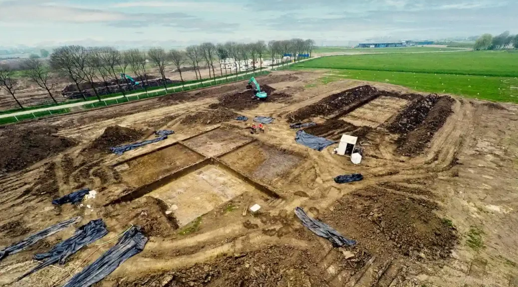
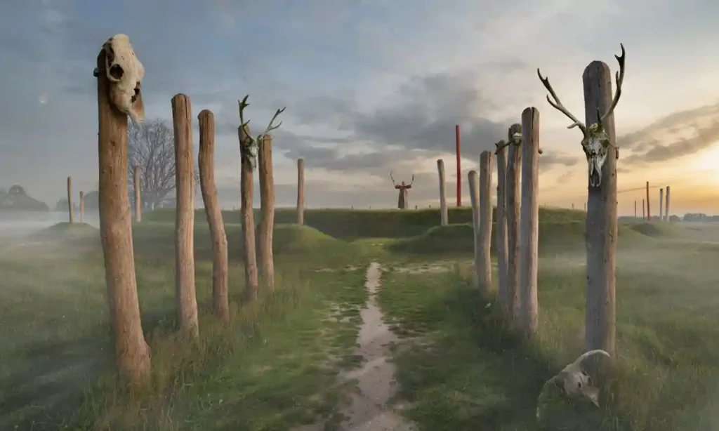
Archaeologists unearth 4,000-year-old ‘Stonehenge of the Netherlands’
The Tiel sanctuary featured a solar calendar that was used to determine important events including festivals and harvest days, say archaeologists.
Dutch archaeologists have unearthed an approximately 4,000-year-old religious site – nicknamed the “Stonehenge of the Netherlands” – that includes a burial mound that served as a solar calendar.
The mound, which contained the remains of about 60 men, women and children, had several passages through which the sun shone directly on the longest and shortest days of the year.
The town of Tiel, where the site was discovered, said on its Facebook page: “What a spectacular archaeological discovery! Archaeologists have found a 4,000-year-old religious sanctuary on an industrial site.”
It added: “This is the first time a site like this has been discovered in the Netherlands.”
Digging on the so-called open-air sanctuary started in 2017 in the small village, about 31 miles (50km) south-east of Utrecht, and the results were made public on Wednesday.
Studying differences in clay composition and colour, the scientists located three burial mounds on the excavations, a few miles from the banks of the Waal River.
An artist’s recreation of the intact sanctuary.
The main mound is about 20 metres (65ft) in diameter and its passages are lined up to serve as a solar calendar. “People used this calendar to determine important moments including festival and harvest days,” the archaeologists said.
NOS, the national broadcaster, added: “This hill reminded one of Stonehenge, the well-known mysterious prehistoric monument in Britain, where this phenomenon also occurs.”
Scientists also discovered two smaller mounds. The three mounds were used as burial sites for about 800 years, the archaeologists said.
They made another fascinating discovery: a single glass bead inside a grave, which after analysis was shown to have originated in Mesopotamia – present-day Iraq.
“This bead travelled a distance of some 5,000km four millennia ago,” the chief researcher, Cristian van der Linde, said.
“Glass was not made here, so the bead must have been a spectacular item as for people then it was an unknown material,” added Stijn Arnoldussen, a professor at the University of Groningen.
He told the NOS the Mesopotamian bead may have been around for a long time before eventually ending up in the area around Tiel, called the Betuwe in Dutch.
“Things were already being exchanged in those times. The bead may have been above ground for hundreds of years before it reached Tiel, but of course, it didn’t have to be,” Arnoldussen said.